
Suchitra Circle Hyderabad carries a name with a specific industrial origin. The area derives it from Suchitra Electronics Ltd., a prominent electronic components manufacturing unit established in what was then a landscape of grape gardens and farmhouses owned by the local Kshatriya community since the 1960s. That electronics company catalysed a transformation from agricultural periphery to urban suburb — and the circle that bears its name now sits at the junction of National Highway 44 and the Bowenpally-Medchal Road in northern Hyderabad’s fastest-growing residential belt. PIN code 500067, with addresses also appearing under 500055 for the Jeedimetla zone. The circle falls under Alwal mandal, part of Greater Hyderabad Municipal Corporation jurisdiction, and is also known as Suchitra Junction or Suchitra X Roads.
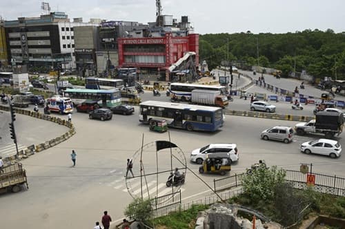
Location and the NH-44 Corridor
Suchitra Circle sits along NH-44 — the highway connecting Hyderabad northward toward Nizamabad and beyond, and southward through the city’s commercial core. The PV Narasimha Rao Expressway, Outer Ring Road, and Bowenpally-Medchal Road all provide connectivity from the circle to the rest of the city. Surrounding localities include Bowenpally, Ammuguda, Kompally, Bolarum, Balanagar, Sainikpuri, and Jeedimetla. Secunderabad Railway Station is approximately 11 km south — the nearest major rail hub.
Rajiv Gandhi International Airport is approximately 38–46 km via NH-44 and the city’s highway network, accessible in roughly 43 minutes under normal conditions, with TSRTC Pushpak airport liner buses available from Suchitra X Roads. TSRTC routes including 10H/25S from Kondapur Bus Depot and 25S/90L from LB Nagar Ring Road serve the junction, connecting it to Hyderabad’s north-south commuter network.
The Metro Question — Phase 2 Is the Answer
The most consistent resident complaint about Suchitra Circle is the absence of metro connectivity — mentioned explicitly and repeatedly in 99acres reviews, Quora discussions, and property listing descriptions. The nearest existing metro station is Suchitra Centre, approximately 1.86 km away on the Blue Line, with Bhudevi Nagar at 3.6 km and Ferozguda at 4.65 km.
This gap changes under Hyderabad Metro Phase 2. Approved in early 2025, Phase 2 includes a 23 km corridor from Paradise to Medchal specifically via Suchitra Circle — a direct confirmation that the circle is on the future metro map. When this corridor is built, Suchitra Circle moves from a metro-deficient suburb to a metro-served node on the Medchal corridor, fundamentally altering its investment profile. No operational date has been confirmed as of mid-2026; Phase 2 timelines in Indian metro projects require verification as construction progresses.
Residential Growth and Property Market
Suchitra Circle’s residential development story is straightforward: north Hyderabad land prices are significantly lower than the western tech corridor (Gachibowli-HITEC City-Madhapur), and the ORR provides reasonable commute access to those employment zones. For mid-income families priced out of Kondapur and Madhapur, Suchitra Circle offers functional urban living at accessible price points.
The zone has hospitals including Konark, Srikara, Renova, Srujana, and Russh Speciality within reach. Supermarkets DMart, More, and Ratnadeep serve daily provisions. Shopping centres South India Shopping Mall, Max, and KLM provide retail access. Silver Oaks International School is among the educational institutions in the zone. RERA-registered luxury projects like Hivision Heights — with 3 BHK flats offering 45-plus amenities, smart features, and possession starting March 2025 — represent the market’s upward movement.
What Still Needs Work
Traffic signals at Suchitra Circle during peak hours require 15–20 minutes to navigate, which is specifically cited in reviews. Road quality in some pockets is poor with potholes. The Manjeera water supply — the primary water source for northern Hyderabad — deteriorates in quality during the monsoon season, with residents recommending reliance on water cans as a practical workaround. Noise pollution from NH-44 traffic is a trade-off for residents in buildings immediately adjacent to the highway.
FAQs About Suchitra Circle Hyderabad
Q1. Why is it called Suchitra Circle in Hyderabad?
The area takes its name from Suchitra Electronics Ltd., an electronic components manufacturing unit established here when the zone was still largely agricultural. The company’s presence catalysed urbanisation, and the circle that formed at the junction retained the name.
Q2. What is the pincode of Suchitra Circle Hyderabad?
PIN code 500067 covers the core Suchitra Circle area. The adjacent Jeedimetla zone on Nizamabad Road uses PIN code 500055.
Q3. Which metro station is nearest to Suchitra Circle?
Suchitra Centre Metro Station is approximately 1.86 km away. However, Hyderabad Metro Phase 2 — approved in early 2025 — includes a specific corridor from Paradise to Medchal via Suchitra Circle, which will bring a metro station directly to the junction once built.
Q4. How far is Secunderabad Railway Station from Suchitra Circle?
Approximately 11 km south via Bowenpally-Medchal Road. TSRTC buses connect the circle to Secunderabad.
Q5. Is Suchitra Circle good for families to live in Hyderabad?
Yes for mid-income families prioritising affordability and north Hyderabad connectivity. The trade-offs are peak-hour traffic, no direct metro currently, inconsistent water quality, and road maintenance gaps. Improving infrastructure and the proposed Phase 2 metro make it a credible long-term residential zone.