
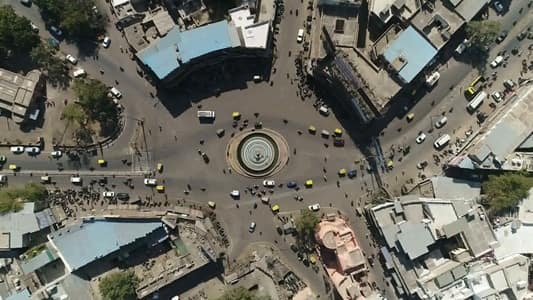
Seven roads. That is the single most important physical fact about Jalori Gate Circle Jodhpur. Every other circle in this series handles three or four. Jalori Gate handles seven — described by local residents and visitors in consistent, independent testimony as a junction where “seven ways originate and pass.” Station Road, Gandhi Hospital Road, Bomba Motor Circle road, the BSNL office corridor, Sojati Gate access, High Court Road, and the old city market belt all converge here. The result is the busiest, most navigationally central intersection in Jodhpur — the circle that Jodhpur locals mean when they say they are meeting “in the middle of the city.”
The Name — Where It Comes From
The name Jalori Gate is older than traffic circles. In the era of the Rathore kings and the princely state of Marwar, the walled city of Jodhpur had multiple gates — entry and exit points through its fortified perimeter, each named for the direction or destination they faced. Jalori Gate was the city gate through which the principal road departed westward toward Jalore (also spelled Jalor) — a historic fortified town in southern Rajasthan, headquarters of an important Marwar subdistrict. The gate through which caravans, armies, and travellers left for Jalore became, in the popular memory, Jalori Gate. The gate structure itself is largely gone or absorbed into the urban fabric, but the name endures as the circle’s identity.
That identity carries specific weight: Jodhpur’s gates were not merely architectural features. They were the regulatory and ceremonial thresholds of a walled medieval city, each associated with the commercial, military, or pilgrimage route it controlled. Jalori Gate’s western orientation placed it on the Jalore-Sindh trade route — one of Marwar’s significant commercial corridors. The commercial character that trade history established persists in the circle’s surrounding market culture today.
Location and the Old City Relationship
Jalori Gate Circle sits at the edge of Jodhpur’s old walled city, where the historic urban fabric meets the newer planned extensions. Sardarpura and Ratanada are the nearest major localities. Umaid Bhawan Palace is approximately 3.5 km east of the circle. Mehrangarh Fort — rising 122 metres above Jodhpur on a hilltop, one of India’s grandest forts — is visible in the skyline from the circle’s zone. Jodhpur Railway Junction is accessible from Station Road heading east from the circle. Central Jail is noted as a landmark near the circle on the Nagar Nigam ward map. Kohinoor Cinema Hall is in the immediate zone. The Bombay Motor Circle junction is a named road connection from Jalori Gate.
What the Circle Is Today
Surrounded by commercial activity of the dense, layered kind that only old Indian city centres generate — street food vendors, clothing shops, electronics, traditional Rajasthani handicraft businesses, bookshops, and the general commerce of a city’s daily life operating at maximum volume. A fountain at the circle’s centre creates an aesthetic feature that is illuminated at night, giving the junction a visual identity beyond its traffic function. The surrounding architecture reflects Jodhpur’s royal heritage in fragments: intricate stonework designs, vivid colours, and building forms that date from different eras of the city’s commercial expansion.
Evening at Jalori Gate Circle is the closest Jodhpur gets to a non-tourist urban spectacle: thousands of vehicles and pedestrians, food vendors at full operation, market stalls lit against the blue-painted old city backdrop visible in the middle distance, and the general organised chaos of a seven-road junction managing itself through sheer familiarity.
Connectivity
Jodhpur Railway Junction — the main station on the Delhi-Jodhpur-Jaisalmer mainline — is accessible directly via Station Road from the circle, approximately 1–1.5 km. No metro exists in Jodhpur. The city’s public transport runs on RSRTC buses and city buses, with auto-rickshaws and app-based cabs supplementing. The seven-road structure of the circle means that getting to any part of central or western Jodhpur from this junction requires navigating one of several clearly marked corridor options — the circle’s multi-directional connectivity is why it functions as Jodhpur’s navigational zero point.
FAQs About Jalori Gate Circle Jodhpur
Q1. Why is it called Jalori Gate Circle?
A: The name comes from a historic city gate in Jodhpur’s old walled city — the Jalori Gate, through which the principal westward road departed toward Jalore (Jalor), a fortified town in southern Rajasthan. The gate was a regulatory and ceremonial threshold of medieval Jodhpur, and its name transferred to the circle that formed at this location.
Q2. How many roads meet at Jalori Gate Circle?
A: Seven roads converge at the circle — making it Jodhpur’s most complex and busiest junction. It connects Station Road, Gandhi Hospital Road, Bomba Motor Circle, the BSNL office corridor, Sojati Gate access, High Court Road, and the old city market belt.
Q3. What is the nearest railway station to Jalori Gate Circle?
A: Jodhpur Railway Junction is approximately 1–1.5 km east via Station Road — the main station on the Delhi-Jodhpur-Jaisalmer mainline, well within walking or short auto distance from the circle.
Q4. How far is Mehrangarh Fort from Jalori Gate Circle?
A: Mehrangarh Fort is visible in the Jodhpur skyline from the circle’s zone and is within the broader old city belt accessible on foot or by auto-rickshaw — approximately 2–3 km depending on route.
Q5. What is the commercial character of Jalori Gate Circle?
A: Dense street-level commerce: food vendors, clothing, electronics, traditional Rajasthani handicrafts, bookshops, and general urban retail. The area is one of Jodhpur’s busiest commercial nodes, operating from morning through late evening, with the circle fountain illuminated at night.